
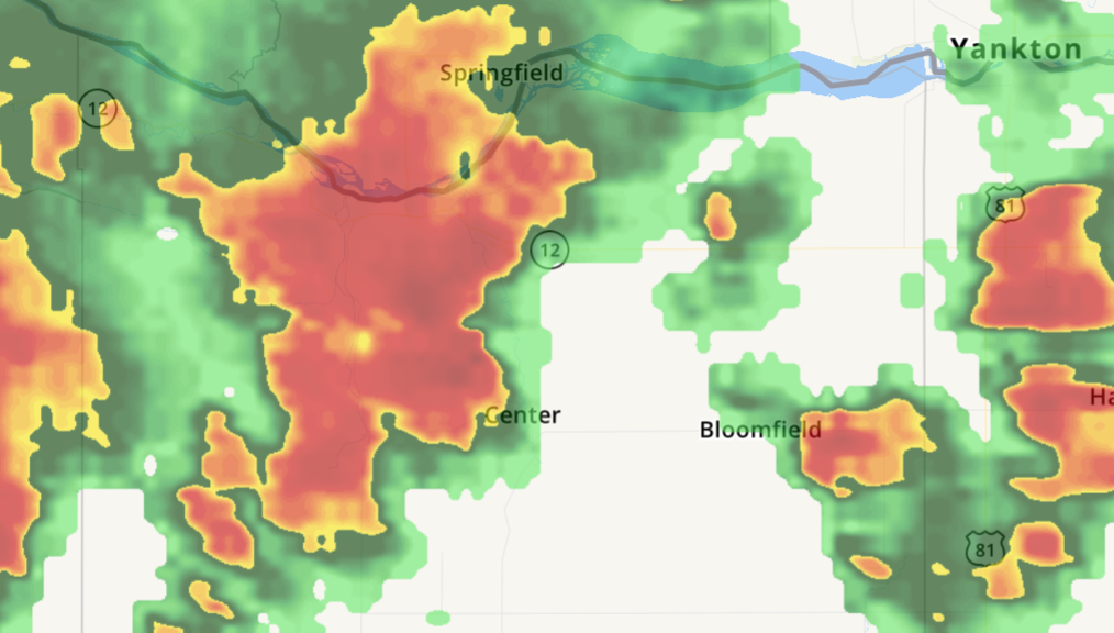
 The National Weather Service is now calling for tennis ball sized hail in the Verdigre, Niobrara, Santee, Crofton, Center, Verdel, Lindy and Lewis & Clark State Recreation Area.
The large hail and 60 mph winds are radar indicated. The storm - as of 7:48 p.m. - was located 7 miles southeast of Niobrara and moving northeast at 30 mph. People and animals outdoors will be injured. Expect hail damage to roofs, siding, windows and vehicles. 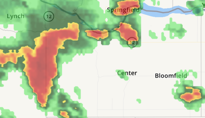 A Thunderstorm Warning has been issued for western Knox County. The storm is moving northeast at 20 mph and producing 60 mph wind gusts and quarter size hail. The warning was issued at 7:16 p.m.
Hail damage to vehicles is expected, along with damage to roofs, siding and trees. Locations impacted include Creighton, Verdigre, Niobrara, Winnetoon, Verdel, Bazile Mills and the Highway 14/59 junction. 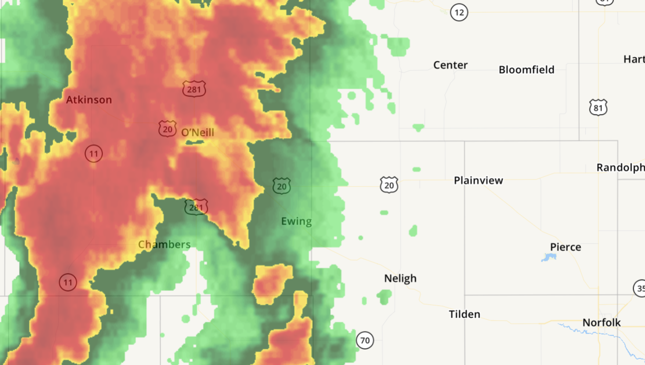 Knox County is now in a severe thunderstorm warning as a storm approaches with 60 mph winds and quarter-size hail.
According to the National Weather Service, the thunderstorm is located near Ewing and moving northeast at 45 mph. Hail damage to vehicles is expected. Locations impacted include Creighton, Bloomfield, Wausa, Verdigre, Crofton, Niobrara, Santee and Verdel.  Special Weather Statement
National Weather Service Omaha/Valley Nebraska 315 PM CDT WED MAY 23 2018 NEZ011-016-017-232045- Pierce NE-Knox NE-Antelope NE- 315 PM CDT WED MAY 23 2018 ...SIGNIFICANT WEATHER ADVISORY FOR NORTHWESTERN PIERCE... NORTHEASTERN ANTELOPE AND SOUTH CENTRAL KNOX COUNTIES UNTIL 345 PM CDT... At 315 PM CDT, Doppler radar was tracking a strong thunderstorm near Plainview, or 31 miles northwest of Norfolk, moving north at 30 mph. Nickel size hail and winds in excess of 30 mph will be possible with this storm. Locations impacted include... Plainview and Creighton. LAT...LON 4224 9780 4232 9796 4250 9792 4252 9778 4244 9766 TIME...MOT...LOC 2015Z 197DEG 24KT 4235 9786 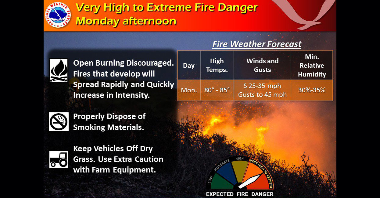 The National Weather Service is asking people to use extra caution on Monday as the area is in Extreme Fire Danger thanks to combination of high temperatures, wind and minimum relative humidity.
Temperatures are expected to reach into the 80s with the wind gusting to 45 mph. The humidity will be 30 to 35 percent. Fires that develop will spread rapidly and quickly as they increase in intensity. Keep vehicles off of dry grass and use extra caution with farm equipment. 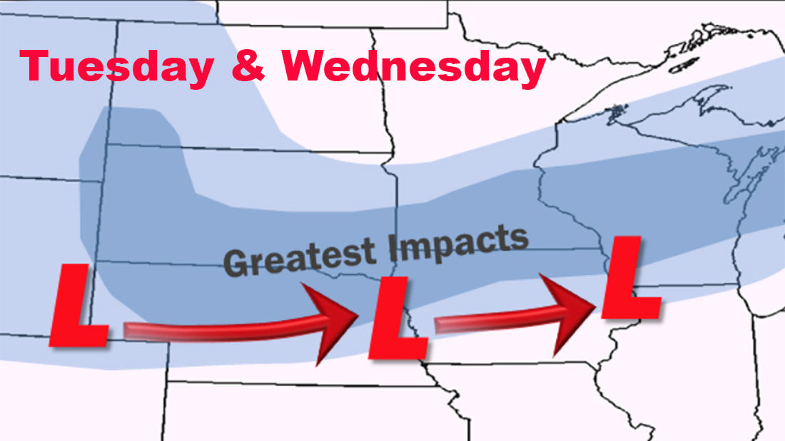 While the sun peaked out Sunday morning through the snow and ice-covered trees, the National Weather Service reminded Northeast Nebraska that winter is not over as they announced another storm on its way.
The next storm is expected to roll through Northeast Nebraska on Tuesday evening and Wednesday, bringing more snow. How much snow will depend on the temperature, but it could be as little as an inch — or much more. The National Weather Service said winds will be 25-35 mph with gusts up to 40 mph. Temperatures are expected to reach 40 degrees on Wednesday but will also be as low as 29 degrees for a possibility of more ice and snow.  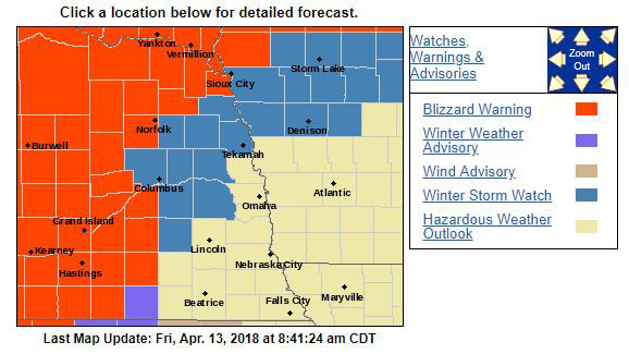 URGENT - WINTER WEATHER MESSAGE National Weather Service Omaha/Valley NE 342 AM CDT Fri Apr 13 2018 ...BLIZZARD CONDITIONS EXPECTED IN NORTHEAST NEBRASKA... EZ011-016-131745- /O.CON.KOAX.BZ.W.0003.180414T0000Z-180415T0000Z/ Knox-Antelope- Including the cities of Creighton, Bloomfield, Crofton, Wausa, Verdigre, Niobrara, Neligh, and Elgin 342 AM CDT Fri Apr 13 2018 ...BLIZZARD WARNING REMAINS IN EFFECT FROM 7 PM THIS EVENING TO 7 PM CDT SATURDAY... * WHAT...Blizzard conditions expected. Winds gusting as high as 45 mph will cause whiteout conditions in blowing snow. Significant drifting of the snow is likely. Total snow accumulations of 10 to 14 inches are expected. * WHERE...Knox and Antelope Counties. * WHEN...From 7 PM this evening to 7 PM CDT Saturday. * ADDITIONAL DETAILS...Travel will be very dangerous to impossible. Tree branches could fall. PRECAUTIONARY/PREPAREDNESS ACTIONS A Blizzard Warning means severe winter weather conditions are expected or occurring. Falling and blowing snow with strong winds and poor visibilities are likely. This will lead to whiteout conditions, making travel extremely dangerous. Do not travel. If you must travel, have a winter survival kit with you. If you get stranded, stay with your vehicle. The latest road conditions for the state you are calling from can be obtained by calling 5 1 1. Friday
A chance of showers and thunderstorms, then showers and possibly a thunderstorm after 9am. Temperature rising to near 45 by 11am, then falling to around 36 during the remainder of the day. Breezy, with a northeast wind 21 to 24 mph, with gusts as high as 33 mph. Chance of precipitation is 90%. New rainfall amounts between a tenth and quarter of an inch, except higher amounts possible in thunderstorms. Friday Night Rain showers before 10pm, then rain and snow showers between 10pm and 11pm, then snow after 11pm. The snow could be heavy at times. Patchy blowing snow after 1am. Low around 26. Windy, with a north wind 29 to 31 mph, with gusts as high as 41 mph. Chance of precipitation is 100%. New snow accumulation of 3 to 7 inches possible. Saturday Snow. The snow could be heavy at times. Areas of blowing snow. High near 28. Windy, with a north wind 26 to 31 mph, with gusts as high as 41 mph. Chance of precipitation is 90%. New snow accumulation of 5 to 9 inches possible. Saturday Night A 30 percent chance of snow before 1am. Patchy blowing snow before 9pm. Mostly cloudy, with a low around 17. Blustery, with a north wind 13 to 23 mph, with gusts as high as 32 mph. Sunday Mostly sunny, with a high near 32. North northwest wind around 15 mph, with gusts as high as 21 mph. Sunday Night Mostly clear, with a low around 14.  ...WINTER WEATHER ADVISORY IN EFFECT FROM 1 AM TO 7 PM CDT TUESDAY...
* WHAT...Mixed precipitation expected. Total snow accumulations of up to 2 inches, with localized amounts up to 4 inches, and minor sleet or ice accumulations are expected. In addition to the precipitation it will be windy. * WHERE...Portions of east central and northeast Nebraska and west central Iowa. * WHEN...From 1 AM to 7 PM CDT Tuesday. Northwest winds will increase to 25 to 35 mph with gusts to 45 mph Tuesday morning and Tuesday afternoon. * ADDITIONAL DETAILS...Plan on slippery road conditions, including during the morning commute on Tuesday. Tree branches could fall. Expect reduced visibilities at times. PRECAUTIONARY/PREPAREDNESS ACTIONS... A Winter Weather Advisory means that periods of snow, sleet or freezing rain will cause travel difficulties. Expect slippery roads and limited visibilities, and use caution while driving. The latest road conditions for the state you are calling from can be obtained by calling 5 1 1. The current radar shows mixed precipitation (pink) over the area with a large line moving into the area with the temperature to determine the type of precipitation.  ...SIGNIFICANT ICING EXPECTED ACROSS NORTHEAST NEBRASKA FROM
LATE TONIGHT INTO FRIDAY NIGHT... .A strong upper level low pressure system will bring precipitation to the Central Plains tonight and into Friday night. Temperatures in northeast Nebraska will drop to around freezing as precipitation develops resulting in areas of freezing rain near the Nebraska and South Dakota border. The rain may mix with sleet and snow, and could end as a mix of snow and freezing rain. ...WINTER STORM WARNING REMAINS IN EFFECT FROM 4 AM FRIDAY TO 1 AM CDT SATURDAY... * WHAT...Heavy mixed precipitation expected. Total snow and sleet accumulations of up to 2 inches and ice accumulations of two tenths to three tenths of an inch are expected. * WHERE...Knox and Cedar Counties. * WHEN...From 4 AM Friday to 1 AM CDT Saturday. * ADDITIONAL DETAILS...Power outages and tree damage are likely due to the ice. Travel will be dangerous and nearly impossible, including during the morning commute on Friday. Be prepared for significant reductions in visibility at times. Recommended actions A Winter Storm Warning means significant amounts of snow, sleet and ice will make travel very hazardous or impossible. The latest road conditions for the state you are calling from can be obtained by calling 5 1 1. |
 RSS Feed